")
The whereabouts
As you see, Nice is on the Eastern bank of a river : the Var. It belongs to a large metropolis spreading from the Esterel mountains West of Cannes to the italian border. It is almost 80km long, and includes among others Cannes, Grasse, Vallauris - Golfe Juan, Antibes, Cagnes sur Mer and St Laurent du Var West of the river, Villefranche sur Mer, Beaulieu sur Mer, Eze, Cap d'Ail Monaco Monte-Carlo, Roquebrune Cap Martin and Menton East of it. You can start your car on the Croisette near the Palais des Festivals in Cannes, ride until the border and stay in town all along. Zoom out two times to see the whole metropolis.
Nice has around 350,000 inhabitants and is the 5th city in France. The whole metropolis totals more than 600,000 inhabitants. Mainland France is divided in 94 "departements". Nice is in the 6th one by alphabetical order : the "Alpes Maritimes" which also includes Cannes, Antibes, Menton, Grasse... That's why you'll see "06" on the registration plates of the local cars.
The city center
The center of the city is Masséna square, where we are (below). In front of you, the main shopping street, Jean Médecin Street, which goes to the main station.
On your left the Albert the 1st garden and on your right the Felix Faure avenue (pan with the camera to see them). They continue each other to form a long green strip, the "Promenade du Paillon". It is actually a river bed which was covered on several kilometers from its mouth. The Paillon still exists and flows under your feet. After the Albert I garden, the Sea. If you make a right from your original position to take the Avenue Felix Faure, you'll discover the new "Promenade du Paillon", then the Theater, the museum of modern art (MAMAC), the library, the Square Head, the congress and the exhibition center Acropolis. All these buidings were built above the river. To see the Paillon, you have to go 3km from the Massena square. (No need to do it, the river has no charm at all.) A little further, a high school was also built on the river bed. Use the map on the right to discover these places.
On your right, if you walk away from the Sea, (i.e. on our back as the camera was in the beginning) the Old town at the foot of the Castle hill (colline du Chateau). This is where the city hall, the courthall and the Opéra are located. On your left when you walk upstream the Paillon the city center with its shopping streets.
Sensible districts
Like in every other town, there are in Nice some places were crime rates are higher. In these places most inhabitants are victims, not drug dealers or molesters. Most of them will welcome you. However, as tourists, it is advised not to park your vehicles there, for exemple. Foreign registration plates are quickly noticed and the cars might be vandalized and the glasses broken to search and steal what's inside. This is true also everywhere in Nice. Do not let anything visible in your car, especially in summer.
Two sensible districts are "les Moulins", West of the city, near the Paul Montel boulevard, and the "Ariane", East.
|
Les Moulins |
L'Ariane |
But other areas, closer from the city center are very similar to these ones. The Pasteur district, along the Pasteur boulevard and near the hospital suffers from the developpment of petty or more serious crime, and drug deals. Same thing for the St Roch area, near the "top" of the St Roch boulevard, the Barel boulevard and the Semard boulevard. (Do not mistake with the St Roch hospital, which is located in an other area.) Those places are located on the Paillon river sides, upstream from the Exhibition center.
|
Pasteur |
St Roch |
A summarized history
The first known inhabitants of Nice settled 400,000 years ago, in Terra Amata, East of the city, near the present harbour.
900 years BC Celts came, and soon Phoceans, the Greeks which founded Marseille. They created here Nikaia, a tiny trading post on the way between Greece and Marseille. Ligurians could also be found. All these people lived together rather peacefully.
Then came the Romans. They settled inland, on a hill. (Cimiez). They created there a real town, Cemenelum, 4 km away from the Sea. The arena and the baths still exist, at least partially. (See archeology museum) The head of the Roman Province was at this time Embrun, today in the High Alps departement. The Romans and the Phoceans also lived together peacefully.
Roman Empire's collapse, barbaric invasions, arabs forays and then inclusion into the Provence county. It's already year 1000.
But Nice is more oriented towards Genova, mainly because it trades so much with this city. In the end Nice becomes an ally of Genova in 1215. The city has at this time moved from the Cimiez hill to the Old town and the Castle hill .
In 1388 Nice leaves the Provence county and joins the Savoy county which spreads on both sides of the Alps, with Torino, today in Italy, as its capital. There will be conflicts, obviously. Because of this Nice won't be French in the next centuries, sharing the more or less bright fate of the Savoy dukedom and the Sardaigne kingdom. All along this period going to the 19th century, Nice is now and then conqueered back by France (Louis XIV, the Revolution, the Empire...).
In the 19th century, the border between France and the Nice county is the Var river. France is on the right bank, West, Nice county (Savoy) on the left bank, East.
To thank Napoleon III and France for their support during the Italian unification, the Nice county is offered to France. But the people wil decide for themselves and vote. It's a huge success and on the whole territory only 90 people vote against the incorporation of Nice into France.
During WWII Nice is first part of the "free zone", administered by the Petain administration. Then, in november 42, it is occupied by the Italians, until september 1943. On the 8th of this month come the Germans. They will stay until the insurrection of the city, in August 44, a few days after the Provence allied landing.
Nice has much spread itself since WWII. In 1950 there was almost nothing West of the boulevard Gambetta.
The July the 14th 2016 slaughter
In the evening, on July the 14th, 2016, more than 40,000 people were gathered on the Promenade des Anglais to enjoy the Prom party concerts and the fireworks of the National day.
A 19 tons truck, driven by an islamic terrorist arrived on the Promenade from the Avenue de Fabron, coming from the urban highway (voie rapide). It was exactly 10:32'32" p.m. according to the anti terrorist police report, based on the cameras recordings.
The road was not closed to traffic there. The part reserved for pedestrians started at the Boulevard Gambetta, and went as far as the Albert the 1st garden. The traffic was slow, though, because of the closing ahead and the diversion.
At the level of the Lenval Hospital, the terrorist turned his lights off and went on the sidewalk to kill as many people as possible. Many victims, with the noise of the traffic on the road didn't even see it come.
10:34'28" p.m. A national police car started chasing the truck on the sidewalk because the traffic was jammed on the road. It was delayed and then blocked by the victims left by the truck behind it and other people fleeing.
In front of the Negresco Hotel, a pergola prevented the truck to go on on the sidewalk and it rode back on the road, closed to all traffic for the party and where a huge and dense crowd wandered.
It kept running over as many people, women, children, men, old people as possible.
10:35'46"p.m. The truck stopped because of an error of the terrorist. The policemen arrived 43 seconds later and opened fire. The shooting lasted 1'15" and stopped at 10.37'44" when the terrorist was shot dead.
In a few minutes, he had killed 84 people and wounded more than 300 others.
Two more victims died within a few weeks in the emergency service of the hospital, raising the death toll to 86. Among the wounded people, many will never walk again normally. Families have been completely annihilated, parents killed in front of their children. 14 children lost their lives in the attack.
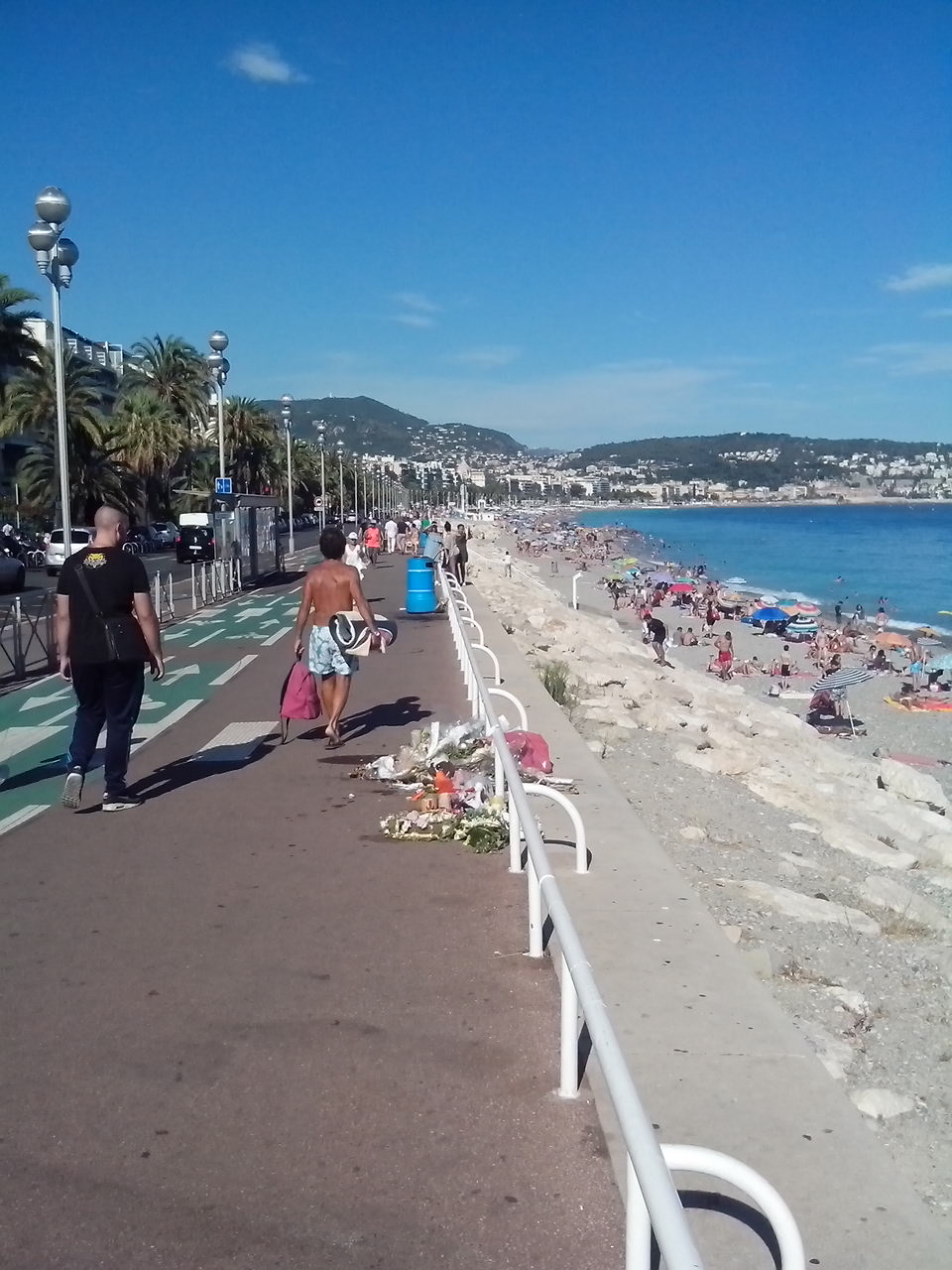
Here fell some of the first victims of the truck. The next ones were near the blue trash can. The last ones, 2 km further.
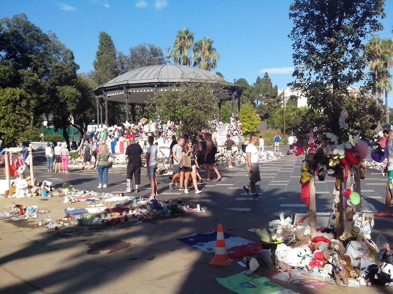
First, all tributes to victims were payed in the Albert 1er garden (picture above), before a hidden monument was erected to commemorate this tragedy, in the garden of the Massena museum.
The climate
Nice is famous for its climate. Some inhabitants sometimes brag so much about it that you might think that they have a part in the nice weather.
We actually owe this climate to the mountains at the Italian border (the Mercantour mountains), North of the city and which top 3200m. They protect us from the cold winds from the North and create a foehn effect on the sea shore. Besides there is also the thermical effect of the Sea which heats the air in winter and cools it down in summer.
In Nice we also have the Mistral, this chilly North wind blowing sometimes in the Rhone valley, Marseille and Toulon. But here it blows from the West and is not as strong, and not as cold. In case of Mistral, you'll see the the airliners turn in final at low height above the Angels bay to line up and land. An impressive view.
In Nice, the bad wind is the Eastern wind. It brings bad weather.
In summer, now and then blows the Sirocco, a hot South wind bringing with him the sand of the Sahara. Don't be surprised if your car, in the morning, is covered with a thin layer of sand.
A typical year
Summer is hot, no surprise, but usually not too hot. Many thunderstorms in the mountains and also on the sea shore. A few years ago these storms used to begin after the 15th of August but lately (green house effect?) we've had them all summer long.
September and October are usually very nice, with still warm temperatures and very little rain.
From the end of October to mid december the weather is more uncertain. We can have rain or grey skies during weeks.
From the end of december to the end of February, it's usually a bright and clear sky, with no sea mist. But there are also sometimes a few days in a row with bad weather. It's luck dependant.
March and the beginning of April : rainy and cloudy weather possible during several days, even weeks in a row.
May and June : the summer is (almost) back.
Of course, Mother Nature doesn't always respect this scheme.
If you want to know the weather in Nice today or the forecast for the next few days use this link.
To have reliable statistics on the climate in Nice use this Meteo France page. Do not be surprised if there is less sun in winter. Days are simply shorter. But we say it again : it is in winter that you'll find the brightest days. That's also in winter that the differences between the weather in Nice and the weather in the Northern parts of France and Europe are the largest. As you guessed, it's our favorite season on the Riviera.
The tide
If you don't know the Mediterranean Sea, you'll discover that there are almost no tides here. The difference between highest and lowest tides is less than 5 to 10 cm, unnoticeable.
The relief
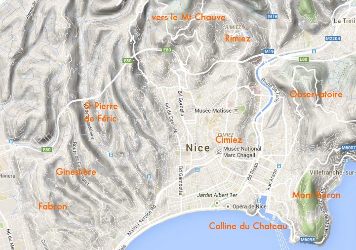
Nice is far from being flat. The hills around are as high as 900m (le Mount Chauve d'Aspremont - the Bald mount, North). The highest point of the town is located on this hill, at 520m high.
The hills around Nice are populated with more exclusive houses than the city center, often with views on the Sea. Cimiez is the closest from the center. That's where the Romans created their city. East, the Mount Boron, topping 200m is a natural border with Villefranche sur Mer. That's where you'll find the most beautiful views on Nice, especially in the morning after sunrise. The observatory is over 300m high, just like the exclusive Rimiez district, North of the town.
The Castle hill beside the harbour is "only" 90m high.
More West, St Pierre de Féric, Ginestière, Fabron, la Lanterne... hills and districts topping small valleys and the Sea.
This relief comes from the fact that Europe and Africa are closing in. Therefore Nice is located in a sismically active area. To know more about the risk and what to do during an earthquake?